Mapping of Moisture Content and Structure of Unsaturated Sand Layers with GPR
ABSTRACT
Many geophysical methods have been developed to map shallow subsurface structures and stratigraphy, from a few centimeters to tens of meters. For depths of few millimeters, classical remote sensing techniques are used, while for the deeper depth ranges, potential and seismic methods are more common. Due to the large demand to development ground infrastructure, there is a need of accurate and reliable mapping of shallow subsurface. An important contribution in the recognition of the shallow subsurface was achieved in the late sixties and in the early seventies with the first development of the Ground Penetrating Radar (GPR).
Typical GPR operates on the principle of transmitting electrornagnetic pulses (frequency range of MHz-GHz) into the ground, and receiving return signals of the reflections from discontinuities zones, based on electrical properties of the subsurface materials. Similar to a seismic reflection profile, a GPR section is a combination of a series of reflections received along a line to simulate a cross-section (profile) of the subsurface. Since the early seventies there have been many improvements in GPR systems and methods. The ease of data acquisition and the ability to understand the electrical characteristics of the subsurface from the analysis of the profiles, make the GPR method a significant tool in high resolution subsurface mapping. This explains the common use of the technique worldwide, and for first time in Israel, in a variety of research areas e.g. hydrology, engineering geology, stratigraphy, neotectonics, archaeology. and others. In the field area of water research, the main application of GPR is the detection and mapping of the water table and of aquifers. The electrical properties of water are distinctly compared to the average geological material. Therefore, the transition from unsaturated layer to a saturated layer is usually a detectable interface on GPR profiles. The quantitative measurement of moisture content with GPR is much more difficult, due to the complexity of the shallow subsurface, and the difficulty to detect and analyze small changes in the profiles (changes that are sometimes smaller than the achieved resolution). In this study. I have gone beyond the common use of GPR, to obtain a quantitative measurements of moisture content of unsaturated layers in sand dunes and to understand the implications of small changes of the moisture content on a scale of a the few meters in the shallow subsurface section.
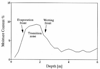
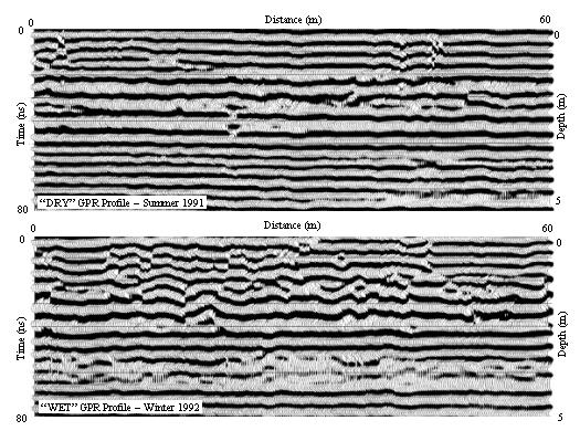
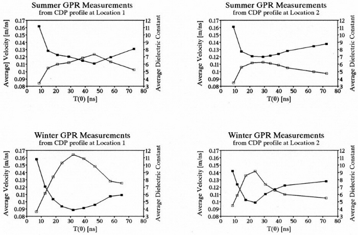
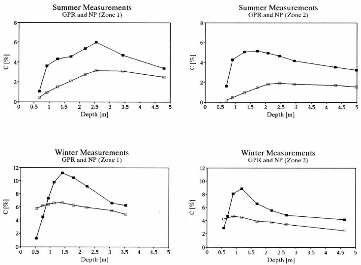
This study was conducted in the desert area of Retamim in the Negev, Israel The area of Retamim is an excellent site to measure moisture content because the Holocene sand dunes are stratified and overlie gravels and chalk. The sand layers of the dune are unsaturated during the entire year, and their moisture content is a function of the granulometric section, the depth, and the season. In any measurement time, especially during the winter, it is possible to find layers and zones in the dune with small changes or large changes in the moisture content (see Figure 1 for a typical log of moisture content of sand dune as a function of depth). Shallow reflection profiles of the dune were collected using pulseEKKO-IV GPR system at two time periods: 1) in the end of the summer when the moisture content of the subsurface was minimal, and 2) in the middle of the winter after an accumulation of 90 mm of rain fall (Figure 2). The main parameter that related to the moisture content of the substance is the dielectric constant . Since there is a relation between the dielectric constant and the propagation velocity of the source wave in the substance, common depth point (CDP) profiles were conducted as a base to the velocity analysis (Figure 3). The complicated relationship between the dielectric constant and the moisture content necessitated a practical model to correlate dielectric values to the moisture content of the dune (Figure 4). During profiling and data analysis, advance seismic and radar techniques were used along with the GPR software and other programs that I wrote to improve the resolution, of the velocity analysis and of the moisture content computations.
The results of the study show the ability of GPR method to measure low values of moisture content in sand dunes, and the power of 3-D mapping of the moisture content from the information of the profiles. The developed model shows the connection between the effective dielectric constant to the moisture content of the dune. Changes of only a few percent in the moisture content led to completely different profiles. In some areas of the dune that display a regular summer profile, have “moisture diffractions in the winter profile. These results shows the strong influence of the moisture content of subsurface materials on the shape of the GPR profile, beyond the accepted estimations of previous studies conducted with a GPR.
FIGURES

Figure 1: Typical water content log of a sand dune in Retamim.

Figure 1: Two GPR profiles which were conducted in the exact same location with the same instrumentation and setting. Note that the differences in the profiles are result of the of the water content changes of the dune due to the different season.

Figure 3: GPR measurements of average dielectric constants (empty squares) and average velocities (filled squares) as a function of time.

Figure 4: Water content as a function of depth. The filled squares ar the GPR measurements. The empty squares are a Neutron Probe control measurements.


