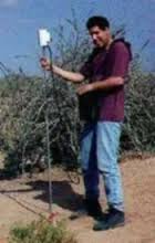
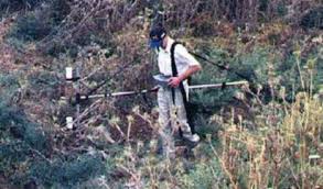
Magnetic methods are used to detect subsurface elements due to spatial variations in the total magnetic field. Residual magnetic fields can be isolated from regional measurements, indicating the existence of typical subsurface bodies. Using a magnetic gradiometer multisensor enables efficient detecting of shallow subsurface bodies. In this method, the total field is measured simultaneously at two elevations by using two sensors on a pole separated by a fixed distance. The difference in magnetic intensity between the two sensors divided by the distance between them is the vertical gradient. This technique reduces interference from solar magnetic storms and regional magnetic changes. This type of survey is used to locate faults, mineralized zones, and underground structures associated with ore deposits, as well as oil fields. Magnetometer surveys are rapid and efficient. Magnetic surveys can be used to locate buried ferro-magnetic objects (barrels, drums and storage tanks) in order to complete site assessment investigations. Detection depends on the amount of magnetic material present and its distance from the sensor. A single steel drum can be detected at burial depths up to around 6 meters. Burial depth can be estimated from magnetometer data collected using the gradient method.
The most common uses for magnetic surveys are:
- location of buried tanks and drums
- geological mapping
- mineral exploration
- archaeology


